
Playing with Maps

“Wait!” he shrieked as I headed to the car for school pick up…
“Wait!! I need to get my map!”
He climbed into the car clutching a crumpled pieces of paper with a lot of lines drawn on it and as we drove the familiar route from home to school he shouted directions to me from the back seat.
That was the beginning of his map obsession. In the week that followed he drew lots and LOTS of maps. Any time we went anywhere, even just walking down the drive way to the letter box, he had to bring a map.
So when I was going through piles of old papers and found a stack of photocopied maps that showed where we live (from the days before everyone had a smart phone or a GPS) I knew exactly what to do with them.
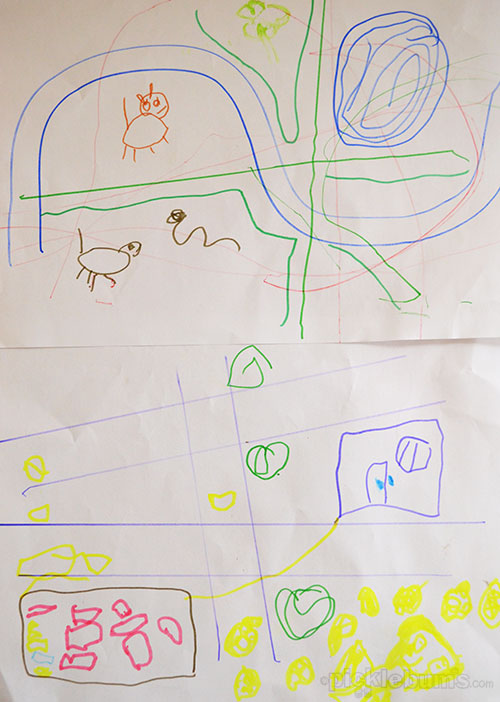
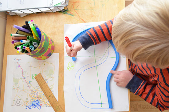
The next time he came to the drawing table he found the stack of maps on the top of the paper basket… along with the ruler, the curve and some thin markers and pencils – map making implements! His eyes lit up!
“Look Mum… a map!”
I sat down on the little seat and put a dot on the map.
“This is where our house is. And this is the road we live on.”
He got the idea quickly and began shooting questions at me.. Where were our neighbors houses? Which way was school? Where was the paddock with the emu in it?
As I pointed he added dots and then ran coloured lines along the roads… “this is the way to the emu… this is the olives….”
Noah sat adding items to the stack of maps for a long time. He took his new map on the drive to school pick up and shouted directions as usual. On the way home he asked me where more things were on his map…
“Where is Nanny’s house? Where is Harper’s house? Where is swimming? Where does Aunty Sue and Aunty Jenny and Great Nan live?”
He got cranky with me when I said those places were not on the map, so when we got home I set about finding a bigger map.
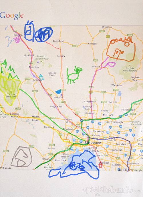
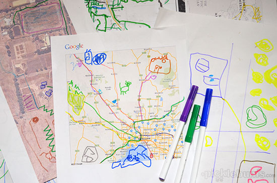
Over the next few days I printed out a google map of Melbourne and the surrounding areas and we added all the places he asked about and more.
There were still some places the map didn’t show, so next came a map of Australia and a map of the world for good measure. The National Geographic education site has a HUGE selection of printable maps.
At three, Noah can’t really grasp what the map of Australia or the world represents, but he enjoyed putting dots on the map where friends and family lived and he loves adding drawings and roads to the printed maps.
To make it more to his scale and easier for him to grasp and to encourage the love of making is own maps I got on google maps again and using a screen capture I printed a satellite photo of our block of land.
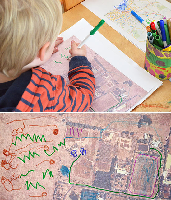
The image is a little fuzzy, but it clearly shows our house, our long driveway, the dam, the sheds, the back yard, the chook house, the big trees up the back, and some of our neighbors and it was a hit. He drew cows in the paddock and a few snakes as well (Dad ran over a snake on the mower the other day so there is a lot of snake talk at our house right now), a road to the big trees, and marked the way to go to school.
Every day he asks me to print out another map, and every day he presents me with a new map to somewhere… you know, just in case I get lost on the way to the supermarket!
Following his interest in maps was easy to do and has been a delight to watch. Just by providing him with a few maps and some drawing materials he’s learned about basic geography, begun to extend his world view, thought about distances and measurement, and practiced all kinds of mark making. But better than that, I’ve barely heard an “I’m bored” since we started our map work which shows me that I have cottoned on to something that really interests him right now. I wonder where his little brain will take us next!
We will definitely be trying this! I have a map lover who likes to draw us a map when we’re going out somewhere and loves to add stickers to our map of NSW of our own travels and where our relatives and friends live. She’ll love this!
I love how you have supported and extended Noey’s interest, it’s inspirational.
This is awesome
Love how you’ve taken his lead
I have a map lover, more so pirate maps but we could definitely tweek this to make it more pirate like ;-)
I love his drawings! :) So awesome that you followed his lead and gave him the tools to pursue it further!
i love this idea. i tried printing some maps, but the lines for the roads do not come up anyone know how to make it darker?
Are you using google maps? I chose the option without the satellite images for our road map so that it would be more ‘map like’ and it printed up smaller than I hoped, but fine.
For the satellite image of our house I tweaked it a little in photoshop as we live in a rural area and so google maps didn’t have a closer image so it was a bit fuzzy, but still fun.
thank you for taking the time to reply! that is lovely :) yes, i used googlemaps. i used the map one but the lines printed very faintly. it might be my printer. i tried another map site too and they were also faint. that is ok. it is a great idea and really fun. i’ll also look out for old map books in the op shop :)
This is so beautiful Kate. A lovely activity to remember doing with him. You’re such a lovely mum to go with his interest, he’ll remember this. And if he doesn’t keep a couple of his maps to pull out when he’s 18 and you ask him to run down to the shops to get some milk and bread.
I’m the map lover in our house, but our almost 6 year old has had a interest as well, he uses the melways street directory in the car and on a recent Melbourne – Sydney road trip I printed a copy of RRA strip maps that he could use to track our progress.
He has also copied a map of our property as we’ll – I love the Curvy ruler – I will be adding one of those to his christmas stocking.
The curve came from Micador if you are looking for one Melissa. We were given it as part of a sponsorship deal but you can get them via their website. :)
I absolutely love maps, and LOVE how your got your little ones curious about them and exploring them!:) How fun!!!!!
I have been saving maps and atlases for years! now, i know why! ha! :)
Just like me… I knew I had shoved that pile of maps into the back of the filing cabinet for a reason! LOL
It’s so lovely when children take learning upon themselves and they don’t even know it! What a wonderful little obsession he has and it’s so lovely how you have supported this. I find paper maps really interesting and say they’re not around as much as they used to be.
It’s funny… I had never noticed how little we use paper maps these days until I found those old maps in the back of the filing cabinet. Only 8 years ago we had to photocopy and give our friends maps as our house was not in the Melways and no one had a GPS back then! Ah how times have changed!
That is so awesome – my boys love maps too. Here are some of our favourite books about maps in case you haven’t come across them. This is me and where I am – Joanne Fitzgerald; As the crow flies Gail Hartman; Mapping Penny’s World – Loreen Leedy; and Where do I live – Neil Chesanow (this one is very USA-centric but easy to adapt to Australia when reading aloud).
Oh thank you for the book list… we are off to the library tomorrow and now I have a list to look for!!!
This post is so timely for me. My daughter has been all about drawing her own maps lately. But I never thought to print out a real map for her to draw on. How fun that your son is showing this interest at age 3!
It really warms my heart to know there are moms and teachers out there still teaching kids to use and appreciate maps! I was a history and geography teacher before staying home with my daughter so this is something I absolutely love and deeply appreciate! Thank you for sharing.
I absolutely love this idea! We will be trying this in our house.
This is fabulous Kate. I’ve never thought about using real maps like this before!! Might work as an extended play thing for our next geocaching adventure! Thank you.
You encouraged his passion and so much more.
That’s awesome! We’ve not gotten into maps here yet but I remember my youngest brother used to love them! He’d pour over the Melways like it was a comic. With Maddie going to School next year, I think we might make a map of her journey from our house to her school. Thanks for sharing.
Great activity. I wonder if I get my girls into map reading at a young age they won’t end up getting disorientated and having to turn the thing upside down and sideways whenever they’re trying to find their way somewhere like I do…
I look after children in my home and am always looking out for different activities for them to do and love this one with he maps. I have printed off maps for my children starting at their house and ending at my place and we are going to go for a drive and take photo’s of things along the way and they can draw them in if they want to. I would also like to extend this by having contact with other in -home educators around the world if anyone would be interested in knowing a bit about New Zealand then we can use the world map to see where everyone lives.
You pretty much have described my 4 year old here. He loves maps and we’re constantly drawing ones up, creating new places and drawing places we have to go to. I never thought of printing maps out for him to draw on and see where we live etc. You have just given my a great idea to keep him occupied (for a bit at least) during our road trip this Xmas. Cheers and thanks for sharing! :)